
 |
| From 2009 November weather |
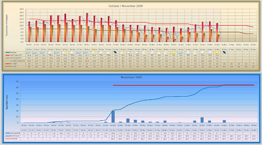
I’ve replaced wind speed with the average daily temperature in chart 1
Now I’ve started keeping temperature records I was giving some thought as to what temperatures I really need to know as a gardener. Certainly daily minimum temperatures are vital to me as a gardener. The first and last frost dates govern the planting and growing of many vegetable crops in my area. Cold nights can stop some crops from growing or at very least give them a set back and delay or even ruin anticipated harvests.
I’m not sure how valuable the daily maximum temperature is to me. I don’t think any crops on the plot have died due to heat – wilted a bit maybe but have always recovered. It’s more of an indication of fine weather. As I’ve got my new weather station set up to give me a record of temperatures every hour I thought I should be able to make better use of this data. I think an average of these 24 temperatures recorded each day to give an average daily temperature should be interesting. It should represent the growing temperature for most of the day.
So I’ve replaced wind speed with the average daily temperature in chart 1 – so this chart now only deals with temperature records whilst chart 2 deals with rainfall records.


0 comments:
Post a Comment
Thank you for visiting my blog and leaving a comment - it is great to know that there are people out there actually reading what I write! Come back soon.
(By the way any comments just to promote a commercial site, or any comments not directly linked to the theme of my blog, will be deleted as soon as I spot them) Please do not follow links from any comments that appear to be spam - if in doubt ignore.